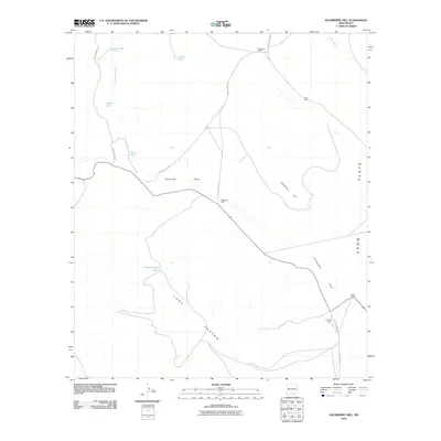
2010 Map of Hackberry Hill
USGS Topo · Published 2010About this map
Hackberry Hill rises above the arid basin of Crow Flats in this 2010 survey of Otero County. The landscape is defined by its water management infrastructure, essential for ranching in the high desert of southern New Mexico. A network of cattle tanks, including Negro Tank, Charlie Tank, and Long Canyon Tank, are scattered across the terrain to catch runoff from seasonal drainages like Jernigan Wash and Piñon Wash. Significant landholdings such as Templeton Ranch and Lewis Ranch anchor the local geography, connected by a sparse grid of gravel routes including County Rd G027. The Presence of Perry Well, Hackberry Well, and the Air Force Well further illustrates the critical reliance on groundwater in this part of the Long Canyon system. The map also traces the winding course of Cornucopia Draw as it cuts through the desert floor.
Find a feature on this map
21 named features on this map. Tap any name to fly to it.
Don’t see what you’re looking for? This feature index may not catch every label — zoom into the map to look around manually.
Map Details
Editions of this 2010 Hackberry Hill Map
This is the sole edition of this map. No revisions or reprints were ever made.
Other maps of this area

1954 · Carlsbad
USGS Topo · 1:250,000

1958 · Carlsbad
USGS Topo · 1:250,000

1963 · Hackberry Hill
USGS Topo · 1:24,000
1963 · Cornucopia Ranch SE
USGS Topo · 1:24,000

1963 · Tanner Ranch
USGS Topo · 1:24,000

1963 · Gowdy Ranch
USGS Topo · 1:24,000

1963 · Panama Ranch
USGS Topo · 1:24,000

1969 · Lewis Canyon
USGS Topo · 1:24,000
1969 · Sheep Draw
USGS Topo · 1:24,000
1970 · Van Winkle Lake
USGS Topo · 1:24,000