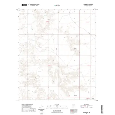
2020 Map of Hackberry Hill
USGS Topo · Published 2020About this map
Hackberry Hill rises above the high-desert landscape of Otero County in this Bureau of Land Management and USGS study. The terrain is defined by a series of intermittent drainage systems and water storage features essential for land management in this arid region. Significant topographic landmarks include the expansive Crow Flats to the east and the deep incision of Long Canyon to the south. The mapping of Jernigan Wash and Cornucopia Draw illustrates the natural runoff patterns that dictate the movement of water across the territory. Man-made water catchments, including Negro Tank, Charlie Tank, Boots Tank, and Green Tank, are scattered throughout the sections, marking vital points for cattle ranching or wildlife. A network of county roads, such as Co RD g024 and Co RD g027, provides the primary access through these townships and ranges, tracing the routes between the isolated ridges and flats.
Find a feature on this map
24 named features on this map. Tap any name to fly to it.
Don’t see what you’re looking for? This feature index may not catch every label — zoom into the map to look around manually.
Map Details
Editions of this 2020 Hackberry Hill Map
This is the sole edition of this map. No revisions or reprints were ever made.
Other maps of this area

1954 · Carlsbad
USGS Topo · 1:250,000

1958 · Carlsbad
USGS Topo · 1:250,000

1963 · Hackberry Hill
USGS Topo · 1:24,000
1963 · Cornucopia Ranch SE
USGS Topo · 1:24,000

1963 · Tanner Ranch
USGS Topo · 1:24,000

1963 · Gowdy Ranch
USGS Topo · 1:24,000

1963 · Panama Ranch
USGS Topo · 1:24,000

1969 · Lewis Canyon
USGS Topo · 1:24,000
1969 · Sheep Draw
USGS Topo · 1:24,000
1970 · Van Winkle Lake
USGS Topo · 1:24,000