
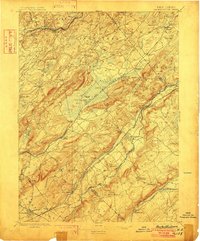
1898 Map of Hackettstown
USGS Topo · Published 1898About this map
The Pequest River and Musconetcong River valleys define the industrial and agricultural landscape of Northwest New Jersey at the end of the nineteenth century. Centered on Hackettstown, the survey reveals a complex network of transportation including the Morris and Essex Division and the New York Susquehanna and Western Railroad, which bypassed significant terrain obstacles like Jenny Jump Mountain. High-altitude water bodies such as Budd Lake (Lake Hopatcong) and Allamuchy Pond sit atop Schooley Mountain and Allamuchy Mountain, providing a stark contrast to the low-lying Great Meadows. Local industry is evidenced by sites like Swayze Mills and the Oxford Tunnel, while smaller hamlets like Vienna, Petersburg, and Townsbury mark the early settlement patterns of Warren and Morris counties before modern suburban expansion.
Find a feature on this map
99 named features on this map. Tap any name to fly to it.
Don’t see what you’re looking for? This feature index may not catch every label — zoom into the map to look around manually.
Map Details
Editions of this 1898 Hackettstown Map
2 editions found
Other maps of this area

1888 · Franklin
USGS Topo · 1:62,500

1888 · Hackettstown
USGS Topo · 1:62,500

1888 · Lake Hopatcong
USGS Topo · 1:62,500

1890 · Easton
USGS Topo · 1:62,500

1890 · High Bridge
USGS Topo · 1:62,500

1891 · Somerville
USGS Topo · 1:62,500

1891 · Easton
USGS Topo · 1:62,500

1891 · Wallpack
USGS Topo · 1:62,500

1891 · Delaware Water Gap
USGS Topo · 1:62,500

1893 · Delaware Water Gap
USGS Topo · 1:62,500