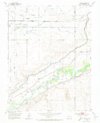
1953 Map of Hadley
USGS Topo · Published 1973About this map
Old Fort Bent (Ruins) and its surrounding history anchor this survey of the High Plains, where the Arkansas River corridor serves as the primary artery for settlement and infrastructure. The landscape is defined by an extensive network of water management systems, including the Fort Lyon Canal, Lewis Lateral, and various flumes and ditches that supported the agricultural economy of the mid-20th century.
Find a feature on this map
29 named features on this map. Tap any name to fly to it.
Don’t see what you’re looking for? This feature index may not catch every label — zoom into the map to look around manually.
Map Details
Editions of this 1953 Hadley Map
3 editions found

Other maps of this area

1891 · Catlin
USGS Topo · 1:125,000

1891 · Higbee
USGS Topo · 1:125,000

1891 · Las Animas
USGS Topo · 1:125,000

1891 · Timpas
USGS Topo · 1:125,000

1893 · Higbee
USGS Topo · 1:125,000

1893 · Las Animas
USGS Topo · 1:125,000

1893 · Catlin
USGS Topo · 1:125,000

1894 · Timpas
USGS Topo · 1:125,000

1953 · Cheraw
USGS Topo · 1:24,000

1953 · Cornelia
USGS Topo · 1:24,000