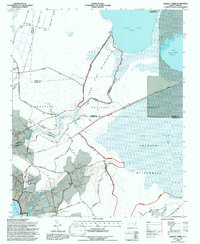
1994 Map of Hadnot Creek
USGS Topo · Published 1997About this map
Croatan National Forest dominates this coastal North Carolina landscape, characterized by the unique wetland ecosystems of the Lakes Pocosin. This 1994 revision, produced for the Forest Service by Mike Cooley, highlights a vast network of wilderness areas including the Great Lake Wilderness and Pocosin Wilderness. The terrain is defined by low-lying swamps and sluggish waterways, where the White Oak River and Hadnot River drain toward the coast. Small signs of human settlement appear in the community of Oyster and near Hadnot Ch, while the interior remains largely a wilderness of fire-adapted pond pines and pocosins. Navigation through this saturated environment is limited to unpaved tracks like Moccasin Road and the Second 4WD Road, alongside access points like the Great Lake Boat Ramp.
Find a feature on this map
43 named features on this map. Tap any name to fly to it.
Don’t see what you’re looking for? This feature index may not catch every label — zoom into the map to look around manually.
Map Details
Editions of this 1994 Hadnot Creek Map
2 editions found
Other maps of this area

1942 · Maysville
USGS Topo · 1:62,500

1942 · Swansboro
USGS Topo · 1:62,500

1948 · Maysville
USGS Topo · 1:62,500

1948 · Swansboro
USGS Topo · 1:62,500

1949 · Havelock
USGS Topo · 1:24,000

1949 · Salter Path
USGS Topo · 1:24,000

1949 · Masontown
USGS Topo · 1:24,000

1951 · Salter Path
USGS Topo · 1:24,000

1951 · Masontown
USGS Topo · 1:24,000

1952 · Hubert
USGS Topo · 1:24,000