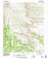
1990 Map of Hagan
USGS Topo · Published 1996About this map
Tonque Pueblo (Site) and the settlement of Hagan anchor this mid-1990s landscape of north-central New Mexico. The geography is defined by an intricate network of desert washes, including Arroyo Tonque and Arroyo Coyote, which cut through the high desert terrain. Notable for its archaeological and historical depth, the area includes the Uña de Gato (Site) and the Tejon Cemetery near the community of Tejon. An Old RR Grade winds through the center of the map, tracing the industrial efforts of a previous era toward the numerous prospects and drill holes scattered across the hills. To the southwest, the boundary of the Cibola National Forest encompasses Cañon Tejon and Cañon Gonzales, while the northern portion is dominated by the San Felipe Indian Reservation. This survey captures a transition from traditional ranching at Diamond Tail Ranch to a landscape of legacy sites and resource exploration.
Find a feature on this map
31 named features on this map. Tap any name to fly to it.
Don’t see what you’re looking for? This feature index may not catch every label — zoom into the map to look around manually.
Map Details
Editions of this 1990 Hagan Map
This is the sole edition of this map. No revisions or reprints were ever made.
Other maps of this area

1892 · San Pedro
USGS Topo · 1:125,000

1954 · Sandia Crest
USGS Topo · 1:24,000

1954 · San Felipe Pueblo
USGS Topo · 1:24,000

1954 · Placitas
USGS Topo · 1:24,000

1954 · Sandia Park
USGS Topo · 1:24,000

1954 · San Pedro
USGS Topo · 1:24,000

1954 · San Felipe Pueblo NE
USGS Topo · 1:24,000

1954 · Hagan
USGS Topo · 1:24,000

1954 · San Felipe Pueblo
USGS Topo · 1:62,500

1956 · Edgewood
USGS Topo · 1:62,500