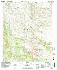
2006 Map of Hagan
USGS Topo · Published 2007About this map
The Town of Tejon Grant defines the center of this landscape, a region marked by its transition from an active mining and ranching corridor to a series of archaeological and historic locations. While many of the once-populated areas are now labeled as sites, the map preserves the precise locations of the Hagan coal mining camp and the Tejon settlement. Genealogy and local history researchers can identify the Tejon Cemetery and the Uña de Gato cemetery further south. The terrain is deeply etched by watercourses such as Arroyo Tonque and Arroyo Coyote, which cut through the northern San Felipe Indian Reservation. Significant ranching infrastructure is still evident at the Diamond Tail Ranch HQ and the southern San Pedro Grant, providing a detailed look at land division and resource extraction in Sandoval County.
Find a feature on this map
38 named features on this map. Tap any name to fly to it.
Don’t see what you’re looking for? This feature index may not catch every label — zoom into the map to look around manually.
Map Details
Editions of this 2006 Hagan Map
This is the sole edition of this map. No revisions or reprints were ever made.
Other maps of this area

1892 · San Pedro
USGS Topo · 1:125,000

1954 · Sandia Crest
USGS Topo · 1:24,000

1954 · San Felipe Pueblo
USGS Topo · 1:24,000

1954 · Placitas
USGS Topo · 1:24,000

1954 · Sandia Park
USGS Topo · 1:24,000

1954 · San Pedro
USGS Topo · 1:24,000

1954 · San Felipe Pueblo NE
USGS Topo · 1:24,000

1954 · Hagan
USGS Topo · 1:24,000

1954 · San Felipe Pueblo
USGS Topo · 1:62,500

1956 · Edgewood
USGS Topo · 1:62,500