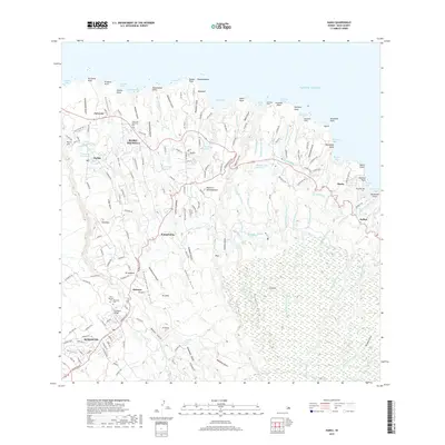
2017 Map of Haiku
USGS Topo · Published 2017About this map
Makawao and Haiku-Pauwela anchor this coastal and agricultural landscape on the northern slopes of Maui. The map reveals a complex infrastructure of water management essential to the region's history, featuring the Haiku Ditch, Lowrie Ditch, and New Hamakua Ditch which cut across the deep gulches of the windward coast. These engineered waterways, alongside reservoirs like Peahi Reservoir and Kapalaalaea Reservoir, illustrate the legacy of sugar cultivation and plantation-era irrigation systems.
Find a feature on this map
181 named features on this map. Tap any name to fly to it.
Don’t see what you’re looking for? This feature index may not catch every label — zoom into the map to look around manually.
Map Details
Editions of this 2017 Haiku Map
This is the sole edition of this map. No revisions or reprints were ever made.
Other maps of this area

1954 · Maui
USGS Topo · 1:250,000

1954 · Paia
USGS Topo · 1:24,000

1954 · Puu O Kali
USGS Topo · 1:24,000

1957 · Kilohana
USGS Topo · 1:24,000

1957 · Haiku
USGS Topo · 1:24,000

1957 · Nahiku
USGS Topo · 1:24,000

1957 · Keanae
USGS Topo · 1:24,000

1966 · Maui
USGS Topo · 1:250,000

1974 · Maui
USGS Topo · 1:250,000
1977 · Paia
USGS Topo · 1:24,000