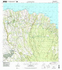
1992 Map of Haiku
USGS Topo · Published 1999About this map
Pauwela Point Lighthouse Pk anchors the northern coastline where the Pacific Ocean meets the rugged North Shore of Maui. This late-twentieth-century landscape is defined by its deep gulches and agricultural infrastructure, including the Kaupakulua Reservoir and Peehi Res, which supported the surrounding settlements of Haiku and Pauwela. Further inland, the terrain ascends toward the Koolau Forest Reserve and Makawao Forest Reserve, revealing a complex network of homesteads and small communities like Kokomo and Makawao. Cultural landmarks such as the 4th Marine Division Memorial Park and the Mau Veterans Cemetery reflect the island's military history. The Hana Highway winds across the northern tier, connecting coastal points like Huelo Point and Honokala Pt through a series of steep drainages, providing a detailed record of the region's transport and topographic character before modern development intensified.
Find a feature on this map
74 named features on this map. Tap any name to fly to it.
Don’t see what you’re looking for? This feature index may not catch every label — zoom into the map to look around manually.
Map Details
Editions of this 1992 Haiku Map
This is the sole edition of this map. No revisions or reprints were ever made.
Other maps of this area

1954 · Maui
USGS Topo · 1:250,000

1954 · Paia
USGS Topo · 1:24,000

1954 · Puu O Kali
USGS Topo · 1:24,000

1957 · Kilohana
USGS Topo · 1:24,000

1957 · Haiku
USGS Topo · 1:24,000

1957 · Nahiku
USGS Topo · 1:24,000

1957 · Keanae
USGS Topo · 1:24,000

1966 · Maui
USGS Topo · 1:250,000

1974 · Maui
USGS Topo · 1:250,000
1977 · Paia
USGS Topo · 1:24,000