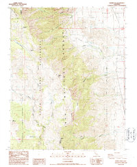
1987 Map of Haiwee Pass
USGS Topo · Published 1987About this map
The Pacific Crest National Scenic Trail winds along the crest of the Sierra Nevada, marking the high-altitude divide between the Sequoia National Forest and the Inyo National Forest. This 1987 survey details the complex hydrography and terrain of the South Sierra Wilderness, where the South Fork Kern River flows near Dutch John Flat. The eastern slopes drop sharply toward the Owens Valley, defined by steep drainage systems like Sage Flat Creek and Hogback Creek.
Find a feature on this map
25 named features on this map. Tap any name to fly to it.
Don’t see what you’re looking for? This feature index may not catch every label — zoom into the map to look around manually.
Map Details
Editions of this 1987 Haiwee Pass Map
2 editions found
Other maps of this area

1905 · Olancha
USGS Topo · 1:125,000

1907 · Olancha
USGS Topo · 1:125,000

1908 · Ballarat
USGS Topo · 1:250,000

1913 · Ballarat
USGS Topo · 1:250,000

1948 · Death Valley
USGS Topo · 1:250,000

1948 · Fresno
USGS Topo · 1:250,000

1951 · Keeler
USGS Topo · 1:62,500

1951 · Haiwee Reservoir
USGS Topo · 1:62,500

1954 · Death Valley
USGS Topo · 1:250,000

1955 · Fresno
USGS Topo · 1:250,000