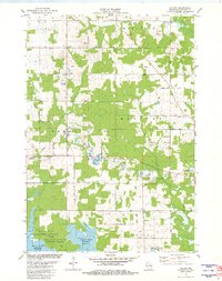
1981 Map of Halder
USGS Topo · Published 1982About this map
Stone extraction and woodlots define the rural character of this Marathon County landscape, where the southern reaches are dominated by the waters of the Big Eau Pleine Reservoir. The small settlement of Halder serves as a local focal point, home to St Patricks Ch and an adjacent Cem, reflecting the community's early social fabric. Numerous Quarries and scattered Quarry sites are mapped throughout the townships of Cassel, Marathon, Emmet, and Mosinee, indicating a long-standing local industry focused on the region's geological resources.
Find a feature on this map
38 named features on this map. Tap any name to fly to it.
Don’t see what you’re looking for? This feature index may not catch every label — zoom into the map to look around manually.
Map Details
Editions of this 1981 Halder Map
This is the sole edition of this map. No revisions or reprints were ever made.
Other maps of this area

1899 · Wausau
USGS Topo · 1:125,000

1902 · Wausau
USGS Topo · 1:125,000

1902 · Marathon
USGS Topo · 1:125,000

1953 · Wausau
USGS Topo · 1:48,000

1953 · Marathon
USGS Topo · 1:48,000

1955 · Green Bay
USGS Topo · 1:250,000

1956 · Milladore
USGS Topo · 1:48,000

1956 · Stevens Point
USGS Topo · 1:48,000

1963 · Wausau West
USGS Topo · 1:24,000

1963 · Marathon
USGS Topo · 1:62,500