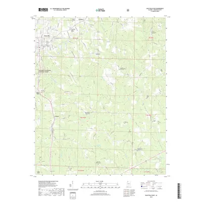
2018 Map of Haleyville East
USGS Topo · Published 2018About this map
The Tennessee Valley Divide cuts through this portion of Winston County, separating the headwaters of several critical drainages. To the west, the Buttahatchee River and Splunge Cr flow toward the Tombigbee system, while the waters of Clear Cr and its numerous tributaries like Little Clear Cr and Tanyard Cr trend toward the Black Warrior basin. This hydrologic divide influenced the early settlement patterns of Haleyville and the surrounding rural communities.
Find a feature on this map
137 named features on this map. Tap any name to fly to it.
Don’t see what you’re looking for? This feature index may not catch every label — zoom into the map to look around manually.
Map Details
Editions of this 2018 Haleyville East Map
This is the sole edition of this map. No revisions or reprints were ever made.
Other maps of this area

1936 · Delmar
USGS Topo · 1:24,000

1936 · Kinlock Spring
USGS Topo · 1:24,000

1936 · Phil Campbell
USGS Topo · 1:24,000

1936 · Moulton
USGS Topo · 1:48,000

1936 · Goddard
USGS Topo · 1:24,000

1940 · Mt Hope
USGS Topo · 1:62,500

1946 · Phil Campbell
USGS Topo · 1:24,000

1947 · Phil Campbell
USGS Topo · 1:24,000

1947 · Kinlock Spring
USGS Topo · 1:24,000
1949 · Kinlock Spring
USGS Topo · 1:24,000