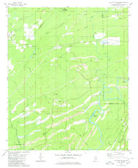
1980 Map of Halfmile Shoals
USGS Topo · Published 1980About this map
The Cahaba River winds through this 1980 survey, defining a landscape marked by heavy industry and small communities along the Bibb, Shelby, and Jefferson county lines. Extensive Strip Mines dominate the southern and central terrain, particularly near McCulley and Belle Ellen, illustrating the region's long-standing reliance on resource extraction. This industrial activity is juxtaposed with the preservation of local history at Tannehill State Park in the north, where the transition from Sand Mountain to the Eastern Valley Road corridor occurs.
Find a feature on this map
51 named features on this map. Tap any name to fly to it.
Don’t see what you’re looking for? This feature index may not catch every label — zoom into the map to look around manually.
Map Details
Editions of this 1980 Halfmile Shoals Map
2 editions found
Other maps of this area

1890 · Bessemer
USGS Topo · 1:125,000

1892 · Bessemer
USGS Topo · 1:125,000

1899 · Brookwood
USGS Topo · 1:125,000

1905 · Bessemer Iron District
USGS Topo · 1:62,500

1907 · Bessemer Special
USGS Topo · 1:62,500

1910 · Montevallo
USGS Topo · 1:62,500

1927 · Adger
USGS Topo · 1:48,000

1932 · Yolande
USGS Topo · 1:62,500

1934 · Blocton
USGS Topo · 1:48,000

1935 · Yolande
USGS Topo · 1:62,500