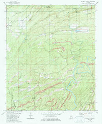
1980 Map of Halfmile Shoals
USGS Topo · Published 1987About this map
The Cahaba River winds through the heart of this landscape, its path defined by natural obstacles like Halfmile Shoals and Lilly Shoals. By the 1970s, the terrain south of Tannehill State Park shows a significant industrial imprint, with extensive strip mines scarring the ridges between the river and the surrounding mountains. These excavations follow the coal-rich seams that long sustained local settlements like Marvel, Garnsey, and Belle Ellen.
Find a feature on this map
50 named features on this map. Tap any name to fly to it.
Don’t see what you’re looking for? This feature index may not catch every label — zoom into the map to look around manually.
Map Details
Editions of this 1980 Halfmile Shoals Map
2 editions found
Other maps of this area

1890 · Bessemer
USGS Topo · 1:125,000

1892 · Bessemer
USGS Topo · 1:125,000

1899 · Brookwood
USGS Topo · 1:125,000

1905 · Bessemer Iron District
USGS Topo · 1:62,500

1907 · Bessemer Special
USGS Topo · 1:62,500

1910 · Montevallo
USGS Topo · 1:62,500

1927 · Adger
USGS Topo · 1:48,000

1932 · Yolande
USGS Topo · 1:62,500

1934 · Blocton
USGS Topo · 1:48,000

1935 · Yolande
USGS Topo · 1:62,500