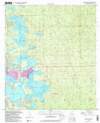
1999 Map of Halfmoon Lake
USGS Topo · Published 2001About this map
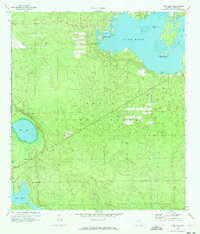
Ocala National Forest dominates this landscape, where the scrub and pine flatwoods are defined by a complex mosaic of lakes and low-lying prairies. The settlement of Lynn sits at the narrow neck between Mill Dam Lake and O'Neil Lake, serving as a focal point for the recreational and residential activity in the area. Evidence of the region's extractive history is visible in several Claypit sites located along the forest's eastern boundary, while local landmarks like Sellers Bear Hole and Snake Island within Half Moon Lake speak to a localized geography of fishing and hunting. Further south, the community of Woods and Lakes and various Trailer Park locations show the pattern of late 20th-century residential growth. The presence of a Lookout Tower near the center of the sheet highlights the forest management infrastructure necessary to protect this sensitive Florida wilderness.
Find a feature on this map
34 named features on this map. Tap any name to fly to it.
Don’t see what you’re looking for? This feature index may not catch every label — zoom into the map to look around manually.
Map Details
Editions of this 1999 Halfmoon Lake Map
This is the sole edition of this map. No revisions or reprints were ever made.
Other maps of this area

1954 · Daytona Beach
USGS Topo · 1:250,000

1958 · Daytona Beach
USGS Topo · 1:250,000

1964 · Daytona Beach
USGS Topo · 1:250,000
1970 · Ft McCoy
USGS Topo · 1:24,000

1970 · Salt Springs
USGS Topo · 1:24,000
1970 · Lynne
USGS Topo · 1:24,000

1970 · Halfmoon Lake
USGS Topo · 1:24,000
1970 · Lake Weir
USGS Topo · 1:24,000
1970 · Lake Kerr
USGS Topo · 1:24,000

1972 · Juniper Springs
USGS Topo · 1:24,000