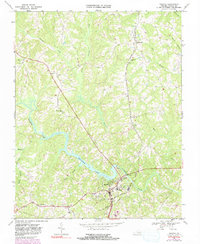
1968 Map of Halifax
USGS Topo · Published 1991About this map
Banister Lake and the Banister River dominate the landscape of southern Halifax County, where the Norfolk and Western railway threads through the regional topography. The town of Halifax serves as a central hub, surrounded by a rural network of named drainages like Terrible Creek and Winn Creek. This 1968 survey, with later photorevisions, documents the essential infrastructure of the era, from the Substation and Sewage Disposal plants to the Pipeline cutting across the countryside. For those tracing local heritage, the map identifies numerous centers of community life, including Bethune High School and Sinai School, alongside several rural congregations such as McKendree Ch, St Pauls Ch, and Murphy Grove Ch. The presence of a Quarry and Gaging Station reflects the active management of the area's natural and industrial resources during the mid-to-late 20th century.
Find a feature on this map
31 named features on this map. Tap any name to fly to it.
Don’t see what you’re looking for? This feature index may not catch every label — zoom into the map to look around manually.
Map Details
Editions of this 1968 Halifax Map
Other maps of this area

1952 · Milton
USGS Topo · 1:62,500

1953 · South Boston
USGS Topo · 1:62,500

1953 · Greensboro
USGS Topo · 1:250,000

1954 · Greensboro
USGS Topo · 1:250,000

1954 · Halifax
USGS Topo · 1:62,500

1954 · Riceville
USGS Topo · 1:62,500

1956 · Milton
USGS Topo · 1:62,500

1957 · South Boston
USGS Topo · 1:62,500

1962 · Greensboro
USGS Topo · 1:250,000

1966 · Greensboro
USGS Topo · 1:250,000