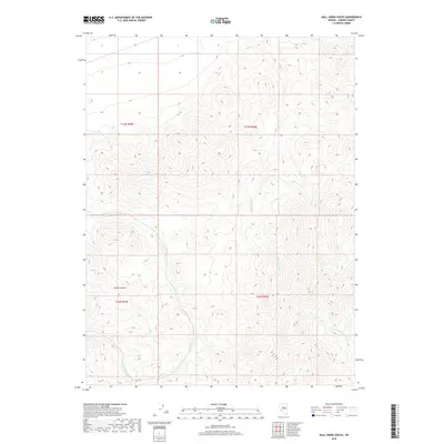
2018 Map of Hall Creek South
USGS Topo · Published 2018About this map
High-altitude drainage basins define this central Nevada landscape, where the Shoshone Mountains' complex topography directs snowmelt into a network of seasonal and perennial streams. The terrain is deeply incised by Picket Canyon, which cuts through the western section of the quadrangle. Hydrological patterns are dominated by the Hall Cr system and its W Fork Hall Cr, while the southern reaches are marked by the headwaters of Iowa Cr and the N Fork Skull Cr. This 2018 survey details the Bureau of Land Management territory within the Toiyabe National Forest, illustrating the traditional range-land divisions of Townships 22 and 23 North across Ranges 44 and 45 East. The map serves as a precise record of the remote riparian corridors like Boone Cr that are critical to the high-desert ecosystem of Lander County.
Find a feature on this map
10 named features on this map. Tap any name to fly to it.
Don’t see what you’re looking for? This feature index may not catch every label — zoom into the map to look around manually.
Map Details
Editions of this 2018 Hall Creek South Map
This is the sole edition of this map. No revisions or reprints were ever made.
Other maps of this area

1926 · Roberts Mountains
USGS Topo · 1:250,000

1929 · Roberts Mountains
USGS Topo · 1:250,000

1955 · Millett
USGS Topo · 1:250,000

1956 · Mount Callaghan
USGS Topo · 1:62,500

1956 · Hall Creek
USGS Topo · 1:62,500

1959 · Millett
USGS Topo · 1:250,000

1969 · Joe Eason Mtn
USGS Topo · 1:24,000

1969 · Vigus Butte NE
USGS Topo · 1:24,000
1969 · Manhattan Mtn NE
USGS Topo · 1:24,000

1979 · Simpson Park Mtns
USGS Topo · 1:100,000