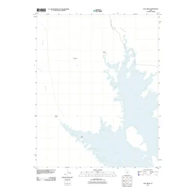
2011 Map of Hall Mesa
USGS Topo · Published 2011About this map
Lake Powell dominates the eastern half of this landscape, its fingers reaching into the canyon network of Glen Canyon National Park. The topographic character of the region is defined by significant vertical relief, where the prominent Hall Mesa stands as a central landmark above the drainage basins. To the west, Halls Creek and Millers Creek snake through the desert floor, while the southern reaches show the intricate shoreline near Baker Ranch. This survey provides a clear look at the hydrologic interface between the reservoir and the natural canyon systems like Long Canyon and Grand Gulch, illustrating the state of the shoreline and local landmarks in the early 21st century. The map serves as a detailed record of the intersections between water, plateau, and ranching history in this remote portion of southern Utah.
Find a feature on this map
9 named features on this map. Tap any name to fly to it.
Don’t see what you’re looking for? This feature index may not catch every label — zoom into the map to look around manually.
Map Details
Editions of this 2011 Hall Mesa Map
This is the sole edition of this map. No revisions or reprints were ever made.
Other maps of this area

1886 · Henry Mountains
USGS Topo · 1:250,000

1892 · Henry Mountains
USGS Topo · 1:250,000

1953 · Mt Pennell 3 NW
USGS Topo · 1:24,000

1953 · Mt Pennell 3 SW
USGS Topo · 1:24,000

1953 · The Rincon
USGS Topo · 1:62,500

1953 · Lake Canyon
USGS Topo · 1:62,500

1953 · Mt. Ellsworth
USGS Topo · 1:62,500

1953 · Hall Mesa
USGS Topo · 1:62,500

1956 · Escalante
USGS Topo · 1:250,000

1960 · Escalante
USGS Topo · 1:250,000