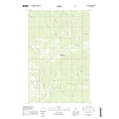
2020 Map of Hall Mountain
USGS Topo · Published 2020About this map
Kaniksu National Forest defines the rugged verticality of this 2020 landscape in northern Boundary County. Dominant peaks like Mission Mtn, Harvey Mtn, and Hall Mtn rise above a complex network of forest roads and trails, including the Pacific NW National Scenic Trail and the Brush Lake Loop. These drainage systems, carved by Mission Cr and Round Prairie Cr, reveal the area's history of high-country access and extraction, evidenced by landmarks such as Tungsten Mtn. The small settlements of Round Prairie and Deer Park sit near the base of these mountains, marking the transition from the valley floor to the high Selkirk and Purcell ridges. This modern survey provides an exact layout of forest service routes like Hall Mountain Rd and specialized OHV paths such as American Girl Ohv.
Find a feature on this map
37 named features on this map. Tap any name to fly to it.
Don’t see what you’re looking for? This feature index may not catch every label — zoom into the map to look around manually.
Map Details
Editions of this 2020 Hall Mountain Map
This is the sole edition of this map. No revisions or reprints were ever made.
Other maps of this area

1911 · Priest Lake
USGS Topo · 1:250,000

1913 · Priest Lake
USGS Topo · 1:250,000

1958 · Sandpoint
USGS Topo · 1:250,000

1963 · Sandpoint
USGS Topo · 1:250,000

1965 · Meadow Creek
USGS Topo · 1:24,000

1965 · Farnham Peak
USGS Topo · 1:24,000

1965 · Eastport
USGS Topo · 1:24,000

1965 · Ritz
USGS Topo · 1:24,000

1965 · Copeland
USGS Topo · 1:24,000

1965 · Hall Mountain
USGS Topo · 1:24,000