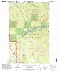
1996 Map of Hall Mountain
USGS Topo · Published 1999About this map
Kaniksu National Forest dominates the landscape of this northern Idaho survey, where the peaks of Hall Mountain and Mission Mountain overlook a region defined by early industrial extraction. The map documents several named mining operations, including the American Girl Mine and Tungsten Hill Mine, alongside the Miller Brothers Mine near Round Prairie. These sites, scattered across the high ridges, reflect the historical mineral exploration that drove development in this remote section of Boundary County.
Find a feature on this map
35 named features on this map. Tap any name to fly to it.
Don’t see what you’re looking for? This feature index may not catch every label — zoom into the map to look around manually.
Map Details
Editions of this 1996 Hall Mountain Map
This is the sole edition of this map. No revisions or reprints were ever made.
Other maps of this area

1911 · Priest Lake
USGS Topo · 1:250,000

1913 · Priest Lake
USGS Topo · 1:250,000

1958 · Sandpoint
USGS Topo · 1:250,000

1963 · Sandpoint
USGS Topo · 1:250,000

1965 · Meadow Creek
USGS Topo · 1:24,000

1965 · Farnham Peak
USGS Topo · 1:24,000

1965 · Eastport
USGS Topo · 1:24,000

1965 · Ritz
USGS Topo · 1:24,000

1965 · Copeland
USGS Topo · 1:24,000

1965 · Hall Mountain
USGS Topo · 1:24,000