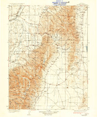
1935 Map of Halleck
USGS Topo · Published 1935About this map
Halleck sits as a vital junction in the high desert of Elko County during the mid-1930s, where the Southern Pacific and Western Pacific railroads converge near the Humboldt River. To the south, the decommissioned site of Fort Halleck marks a point of transition between the early military frontier and the ranching economy established at Starr Ranch and Warm Springs Ranch. The landscape is defined by the sharp divide between the irrigated valley floors and the steep terrain of the East Humboldt Range and Ruby Mountains, connected by the strategic Secret Pass.
Find a feature on this map
104 named features on this map. Tap any name to fly to it.
Don’t see what you’re looking for? This feature index may not catch every label — zoom into the map to look around manually.
Map Details
Editions of this 1935 Halleck Map
3 editions found
Other maps of this area

1934 · Jiggs
USGS Topo · 1:125,000

1935 · Halleck
USGS Topo · 1:125,000

1937 · Jiggs
USGS Topo · 1:125,000

1953 · Spruce Mountain
USGS Topo · 1:62,500

1955 · Wells
USGS Topo · 1:250,000

1955 · Elko
USGS Topo · 1:250,000

1958 · Wells
USGS Topo · 1:250,000

1958 · Elko
USGS Topo · 1:250,000

1959 · Jiggs
USGS Topo · 1:62,500

1961 · Wells
USGS Topo · 1:250,000