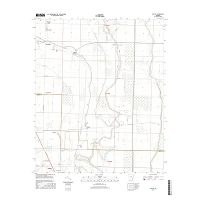
2017 Map of Halley
USGS Topo · Published 2017About this map
McGehee anchor the northern reaches of this landscape where the alluvial plains of Southeast Arkansas meet a complex network of waterways. The area is defined by the winding paths of Crooked Bayou and Boggy Bayou, which dictate the placement of rural roads and the boundaries of agricultural fields. Settlement patterns follow the higher ground near the bayous, notably at Trippe Junction and Halley, where the intersection of state highways and country roads historically facilitated local trade. Genealogists and local historians will find significant value in the distribution of family and community burial grounds, including Bowie Cem, Old Grange Cem, and Beasley Cem, which are scattered throughout the low-lying terrain. The transition between Desha and Chicot counties is clearly marked, illustrating the geopolitical divisions that shaped this portion of the Delta. From the Mc Gehee Municipal Airport down to Bellaire, the map provides a look at the modern drainage and land management systems, such as Canal Number 18, that sustain the region's agricultural economy.
Find a feature on this map
50 named features on this map. Tap any name to fly to it.
Don’t see what you’re looking for? This feature index may not catch every label — zoom into the map to look around manually.
Map Details
Editions of this 2017 Halley Map
This is the sole edition of this map. No revisions or reprints were ever made.
Other maps of this area

1933 · Lamont
USGS Topo · 1:62,500

1936 · McGehee
USGS Topo · 1:62,500

1936 · Lake Village
USGS Topo · 1:62,500

1937 · McGehee
USGS Topo · 1:62,500

1939 · Refuge
USGS Topo · 1:62,500

1939 · Lamont
USGS Topo · 1:62,500

1953 · Greenwood
USGS Topo · 1:250,000

1955 · Lake Village
USGS Topo · 1:62,500

1955 · McGehee
USGS Topo · 1:62,500

1956 · Greenwood
USGS Topo · 1:250,000