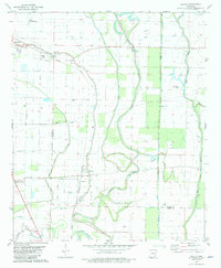
1981 Map of Halley
USGS Topo · Published 1982About this map
The Missouri Pacific railroad corridor anchors this early 1980s landscape, serving as a transit spine through the Arkansas Delta. The winding course of Bayou Macon snakes across the terrain, accompanied by a complex network of artificial waterways including Canal No 19 and Canal No 18. This infrastructure reflects the intensive agricultural management of the region at the time. Small rural settlements like Halley and Bellaire are documented alongside vital community landmarks such as Providence Ch and St James Ch. Genealogists can find several family-named or local burial sites, including Beasley Cem and Old Grange Cem, which sit near the borders of Chicot and Desha counties. The transition from the municipal hub of McGehee in the northwest to the low-lying wetlands of Boggy Bayou reveals the distinct contrast between developed town centers and the managed river bottoms.
Find a feature on this map
30 named features on this map. Tap any name to fly to it.
Don’t see what you’re looking for? This feature index may not catch every label — zoom into the map to look around manually.
Map Details
Editions of this 1981 Halley Map
This is the sole edition of this map. No revisions or reprints were ever made.
Other maps of this area

1933 · Lamont
USGS Topo · 1:62,500

1936 · McGehee
USGS Topo · 1:62,500

1936 · Lake Village
USGS Topo · 1:62,500

1937 · McGehee
USGS Topo · 1:62,500

1939 · Refuge
USGS Topo · 1:62,500

1939 · Lamont
USGS Topo · 1:62,500

1953 · Greenwood
USGS Topo · 1:250,000

1955 · Lake Village
USGS Topo · 1:62,500

1955 · McGehee
USGS Topo · 1:62,500

1956 · Greenwood
USGS Topo · 1:250,000