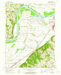
1961 Map of Halls
USGS Topo · Published 1962About this map
The Missouri River defines the western edge of this 1961 landscape, snaking past the small settlement of Palermo and carving a path through the alluvial floodplain. The river's historical shifts are evidenced by numerous oxbow features and former channels, such as Contrary Lake, Muskrat Lake, and Horseshoe Lake. These water bodies dominate the central bottomlands between the townships of Washington and Wayne, reflecting the complex hydrology of the region before modern channel stabilization fully altered these natural cycles.
Find a feature on this map
31 named features on this map. Tap any name to fly to it.
Don’t see what you’re looking for? This feature index may not catch every label — zoom into the map to look around manually.
Map Details
Editions of this 1961 Halls Map
2 editions found
Other maps of this area

1885 · Atchison
USGS Topo · 1:125,000

1888 · Atchison
USGS Topo · 1:125,000

1893 · Atchison
USGS Topo · 1:125,000

1924 · St. Joseph
USGS Topo · 1:62,500

1926 · Atchison
USGS Topo · 1:62,500

1926 · Saint Joseph
USGS Topo · 1:62,500

1926 · Oregon
USGS Topo · 1:62,500

1927 · Dearborn
USGS Topo · 1:62,500

1950 · Kansas City
USGS Topo · 1:250,000
1951 · De Kalb
USGS Topo · 1:24,000