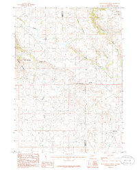
1986 Map of Halls Meadow Spring
USGS Topo · Published 1986About this map
The Continental Divide traverses this high-altitude landscape along the border of Sublette and Fremont counties, marking a critical hydrological and geographic boundary in the American West. At the time of this mid-1980s survey, the area remained largely undeveloped, characterized by a complex network of seasonal and perennial watercourses including the Sweetwater River and Lander Creek. To the west, the Prospect Mountains rise sharply, while the northeastern corner of the map captures a portion of the Bridger National Forest. The presence of the Halls Meadow Spring in the southeast indicates a vital water source in this arid environment, situated near the headwaters of Hay Creek. This provisional survey preserves the precise alignment of unimproved roads and trails used by ranchers and outdoorsmen before the digital era.
Find a feature on this map
11 named features on this map. Tap any name to fly to it.
Don’t see what you’re looking for? This feature index may not catch every label — zoom into the map to look around manually.
Map Details
Editions of this 1986 Halls Meadow Spring Map
This is the sole edition of this map. No revisions or reprints were ever made.
Other maps of this area

1953 · Christina Lake
USGS Topo · 1:24,000

1955 · Lander
USGS Topo · 1:250,000

1958 · Lander
USGS Topo · 1:250,000

1958 · Parting of the Ways
USGS Topo · 1:62,500

1958 · Hay Meadow Reservoir
USGS Topo · 1:24,000

1958 · Pacific Springs
USGS Topo · 1:24,000

1958 · Parting of the Ways
USGS Topo · 1:24,000

1961 · Lander
USGS Topo · 1:250,000

1969 · Jensen Meadows
USGS Topo · 1:24,000
1969 · Sweetwater Needles
USGS Topo · 1:24,000