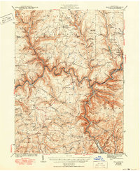
1943 Map of Hallton
USGS Topo · Published 1950About this map
The winding Clarion River defines the central topography of this 1940 survey, slicing through the deep plateaus of the Allegheny Forest region. The settlement of Halton and the industrial activity at Portland Mills anchor the riverfront, while the Baltimore and Ohio RR tracks follow the valley floor. Away from the water, the landscape is marked by a network of upland camps and rural schoolhouses such as Lake City Sch and Millstone High Sch, reflecting a community tied to the timber and resource extraction of the era.
Find a feature on this map
113 named features on this map. Tap any name to fly to it.
Don’t see what you’re looking for? This feature index may not catch every label — zoom into the map to look around manually.
Map Details
Editions of this 1943 Hallton Map
3 editions found

Other maps of this area

1918 · Loleta
USGS Topo · 1:62,500

1922 · Du Bois
USGS Topo · 1:62,500

1924 · Du Bois
USGS Topo · 1:62,500

1924 · Brookville
USGS Topo · 1:62,500

1926 · Brookville
USGS Topo · 1:62,500

1929 · Penfield
USGS Topo · 1:62,500

1932 · Penfield
USGS Topo · 1:62,500

1934 · Kane
USGS Topo · 1:48,000

1935 · Sheffield
USGS Topo · 1:48,000

1935 · Mt. Jewett
USGS Topo · 1:48,000
Featured Places
- Warsaw Township, PA
- Millstone Township, PA
- Polk Township, PA
- Lake City, Spring Creek Township
- Snyder Township, PA