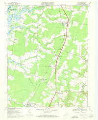
1968 Map of Hallwood
USGS Topo · Published 1971About this map
The Pocomoke River and its intricate network of tributaries like Pitts Creek and Bullbegger Creek define the northern border of this Virginia Eastern Shore landscape. In the late 1960s, the corridor between New Church and Hallwood was a patchwork of small agricultural settlements and rural infrastructure. The Penn Central railroad tracks run parallel to U S Highway 13, anchoring a string of communities including Oak Hall, Lecato, and Temperanceville. Local life centered around country institutions such as Jerusalem Ch, Friendship Ch, and Atlantic High Sch, while numerous small cemeteries and landmarks like Jenkins Bridge offer specific points of interest for genealogical research. The presence of several sandpits and Tunnels Mill suggests a landscape shaped by both natural resources and long-standing local industry. In the eastern portion, the settlement of Atlantic serves as a gateway toward the coast, supported by a network of winding branches like Assawoman Creek.
Find a feature on this map
51 named features on this map. Tap any name to fly to it.
Don’t see what you’re looking for? This feature index may not catch every label — zoom into the map to look around manually.
Map Details
Editions of this 1968 Hallwood Map
4 editions found
Other maps of this area

1901 · Snow Hill
USGS Topo · 1:62,500

1942 · Kingston
USGS Topo · 1:24,000

1942 · Mappsville
USGS Topo · 1:24,000

1942 · Wallops Island
USGS Topo · 1:24,000

1942 · Saxis
USGS Topo · 1:24,000

1942 · Parksley
USGS Topo · 1:24,000

1943 · Parksley
USGS Topo · 1:31,680

1943 · Saxis
USGS Topo · 1:31,680

1943 · Mappsville
USGS Topo · 1:31,680

1943 · Chincoteague West
USGS Topo · 1:31,680