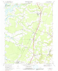
1968 Map of Hallwood
USGS Topo · Published 1991About this map
The Penn Central corridor serves as the backbone of this Eastern Shore landscape, connecting a string of rural communities from New Church in the north down through Oak Hall, Temperanceville, and Hallwood. This 1960s survey documents the traditional agricultural and transit patterns of Accomack County just before modern developmental shifts, showing the area's reliance on both the rail line and a network of winding waterways like the Pocomoke River and Assawoman Creek.
Find a feature on this map
47 named features on this map. Tap any name to fly to it.
Don’t see what you’re looking for? This feature index may not catch every label — zoom into the map to look around manually.
Map Details
Editions of this 1968 Hallwood Map
4 editions found
Other maps of this area

1901 · Snow Hill
USGS Topo · 1:62,500

1942 · Kingston
USGS Topo · 1:24,000

1942 · Mappsville
USGS Topo · 1:24,000

1942 · Wallops Island
USGS Topo · 1:24,000

1942 · Saxis
USGS Topo · 1:24,000

1942 · Parksley
USGS Topo · 1:24,000

1943 · Parksley
USGS Topo · 1:31,680

1943 · Saxis
USGS Topo · 1:31,680

1943 · Mappsville
USGS Topo · 1:31,680

1943 · Chincoteague West
USGS Topo · 1:31,680