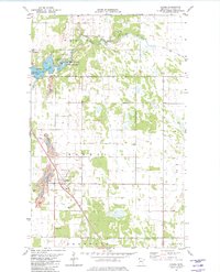
1982 Map of Halma
USGS Topo · Published 1982About this map
Lake Bronson State Park dominates the northwestern corner of this Kittson County landscape, centered on the waters of Lake Bronson and Bronson Lake. The terrain is characterized by a mix of wetlands and agricultural drainage, notably shaped by State Ditch No 95 and State Ditch No 49, which support the flow of the South Branch of the Two Rivers. The small settlement of Halma serves as a local hub along the Soo Line railroad, which cuts diagonally across the township boundaries of Norway, Percy, and Deerwood.
Find a feature on this map
20 named features on this map. Tap any name to fly to it.
Don’t see what you’re looking for? This feature index may not catch every label — zoom into the map to look around manually.
Map Details
Editions of this 1982 Halma Map
This is the sole edition of this map. No revisions or reprints were ever made.
Other maps of this area

1918 · Hemmington
USGS Topo · 1:62,500

1919 · Pelan
USGS Topo · 1:62,500

1930 · Juneberry
USGS Topo · 1:31,680

1932 · Juneberry
USGS Topo · 1:62,500

1952 · Thief River Falls
USGS Topo · 1:250,000

1956 · Thief River Falls
USGS Topo · 1:250,000

1956 · Karlstad
USGS Topo · 1:62,500

1957 · Thief River Falls
USGS Topo · 1:250,000

1957 · Pelan
USGS Topo · 1:62,500

1966 · Skull Lake SE
USGS Topo · 1:24,000