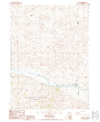
1986 Map of Halsey
USGS Topo · Published 1987About this map
Halsey occupies the northern bank of the Middle Loup River in this mid-1980s topographical study. The landscape is characterized by the expansive plantation of the Nebraska National Forest, which blankets the terrain south of the river valley. The transition from the sandy, undulating topography of the north to the dense timber of the forest is a defining characteristic of this section of the Sandhills region. The map documents the rural ranching culture of the era, specifically identifying the A L Ranch and Rodocker Ranch as significant local landmarks. Industrial activity is represented by a Gravel Pit near the river, while the political boundary between Thomas Co and Blaine Co bisects the area, highlighting the town's position at the county line.
Find a feature on this map
7 named features on this map. Tap any name to fly to it.
Don’t see what you’re looking for? This feature index may not catch every label — zoom into the map to look around manually.
Map Details
Editions of this 1986 Halsey Map
This is the sole edition of this map. No revisions or reprints were ever made.
Other maps of this area

1948 · Halsey
USGS Topo · 1:62,500

1949 · Purdum
USGS Topo · 1:62,500

1949 · Koshopah
USGS Topo · 1:62,500

1950 · Halsey
USGS Topo · 1:62,500

1951 · Dunning
USGS Topo · 1:62,500

1951 · Purdum
USGS Topo · 1:62,500

1951 · Koshopah
USGS Topo · 1:62,500

1954 · North Platte
USGS Topo · 1:250,000

1956 · North Platte
USGS Topo · 1:250,000

1957 · North Platte
USGS Topo · 1:250,000