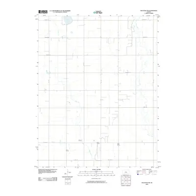
2009 Map of Halstead NW
USGS Topo · Published 2009About this map
Lake Inman and the meandering waters of Turkey Creek define the agricultural prairie of Reno County as it appeared in the early 21st century. The landscape is structured by a rigid section-line grid, where roads like Cheyenne Rd and Buckskin Rd partition the plains into productive fields. This agrarian continuity is punctuated by markers of local heritage and resource extraction, notably the Hollow Nikkel Oil Field.
Find a feature on this map
20 named features on this map. Tap any name to fly to it.
Don’t see what you’re looking for? This feature index may not catch every label — zoom into the map to look around manually.
Map Details
Editions of this 2009 Halstead NW Map
This is the sole edition of this map. No revisions or reprints were ever made.
Other maps of this area

1891 · Hutchinson
USGS Topo · 1:125,000

1893 · Hutchinson
USGS Topo · 1:125,000

1955 · Hutchinson
USGS Topo · 1:250,000

1959 · Hutchinson
USGS Topo · 1:250,000
1959 · Halstead
USGS Topo · 1:24,000
1959 · Burrton
USGS Topo · 1:24,000
1961 · Hutchinson SE
USGS Topo · 1:24,000

1964 · Conway
USGS Topo · 1:24,000

1965 · Mc Pherson South
USGS Topo · 1:24,000

1965 · Halstead NW
USGS Topo · 1:24,000