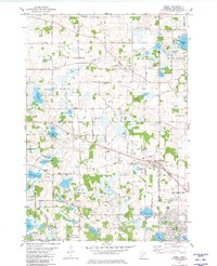
1981 Map of Hamel
USGS Topo · Published 1981About this map
Hamel serves as a central hub in this landscape of shifting boundaries and glacial lakes during the early 1980s. The region is defined by the corporate lines of Corcoran, Maple Grove, Plymouth, and Medina, reflecting a transition from traditional agricultural patterns to suburban development. Transportation follows the Soo Line railroad and an established grid of local routes like Chippewa Road and Settlers Road. Local heritage is anchored by several historic religious sites, including St Johns Ch, Old St Thomas Cem, and Holy Name Cem. Natural features such as Weaver Lake and Jubert Lake dominate the terrain, while newer leisure infrastructure like the Drive-in Theater, Rolling Green Country Club, and the expansive Morris T Baker County Park indicate the area's growing role as a residential and recreational corridor.
Find a feature on this map
87 named features on this map. Tap any name to fly to it.
Don’t see what you’re looking for? This feature index may not catch every label — zoom into the map to look around manually.
Map Details
Editions of this 1981 Hamel Map
2 editions found
Other maps of this area

1896 · Minneapolis
USGS Topo · 1:62,500

1901 · Minneapolis
USGS Topo · 1:62,500

1902 · Anoka
USGS Topo · 1:62,500

1905 · Minnetonka
USGS Topo · 1:62,500

1907 · Minnetonka
USGS Topo · 1:62,500

1909 · Rockford
USGS Topo · 1:62,500

1953 · Saint Paul
USGS Topo · 1:250,000

1953 · Stillwater
USGS Topo · 1:250,000

1954 · Hopkins
USGS Topo · 1:24,000

1954 · Minneapolis
USGS Topo · 1:62,500