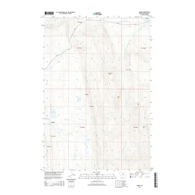
2014 Map of Hamen
USGS Topo · Published 2014About this map
Loweth and Hamen sit at the hydraulic divide of Central Montana, where the headwaters of two major river systems originate. This survey shows the delicate water management of the high plains, featuring several man-made catchments like the Hamen Reservoir, Higgins Reservoir, and Lucas Reservoir. These water sources are essential in a landscape defined by seasonal drainages such as Woodson Cr and Sixteenmile Cr.
Find a feature on this map
30 named features on this map. Tap any name to fly to it.
Don’t see what you’re looking for? This feature index may not catch every label — zoom into the map to look around manually.
Map Details
Editions of this 2014 Hamen Map
This is the sole edition of this map. No revisions or reprints were ever made.
Other maps of this area

1886 · Little Belt Mts.
USGS Topo · 1:250,000

1894 · Little Belt Mts.
USGS Topo · 1:250,000

1897 · Little Belt Mts.
USGS Topo · 1:250,000

1898 · Little Belt Mts.
USGS Topo · 1:250,000

1902 · Little Belt Mts.
USGS Topo · 1:250,000

1948 · White Sulphur Springs
USGS Topo · 1:250,000

1951 · Sixteen NE
USGS Topo · 1:24,000

1951 · Hamen
USGS Topo · 1:24,000
1951 · Wolf Hill
USGS Topo · 1:24,000
1951 · Ringling
USGS Topo · 1:24,000