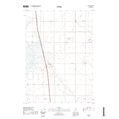
2020 Map of Hamer
USGS Topo · Published 2020About this map
Hamer sits at the center of a high-desert landscape defined by complex water management and distinct volcanic rises. The settlement is positioned along the N Old Butte Hwy, serving as a hub for a network of rural roads such as Peterson Rd and Black Rd. To the west, the hydrology is marked by a series of specialized water bodies including Rat Farm Pond, Willow Pond, and Muskrat Pond, alongside the larger Sandhole Lake. These features, coupled with the Hamer Ditch and Camas Cr, suggest a land heavily utilized for irrigation and waterfowl habitat. The horizon is broken by the prominent elevations of Beacon Butte and Raumaker Butte to the east, while the Jefferson and Fremont county line bisects the northeastern corner of the quadrangle, illustrating the administrative boundaries that overlay this eastern Idaho terrain.
Find a feature on this map
30 named features on this map. Tap any name to fly to it.
Don’t see what you’re looking for? This feature index may not catch every label — zoom into the map to look around manually.
Map Details
Editions of this 2020 Hamer Map
This is the sole edition of this map. No revisions or reprints were ever made.
Other maps of this area

1955 · Dubois
USGS Topo · 1:250,000

1955 · Idaho Falls
USGS Topo · 1:250,000

1958 · Dubois
USGS Topo · 1:250,000

1958 · Idaho Falls
USGS Topo · 1:250,000
1964 · Market Lake
USGS Topo · 1:24,000
1964 · Deer Parks
USGS Topo · 1:24,000

1964 · Mud Lake SE
USGS Topo · 1:24,000
1964 · Hamer
USGS Topo · 1:24,000

1964 · Camas
USGS Topo · 1:24,000

1964 · Rays Lake
USGS Topo · 1:24,000