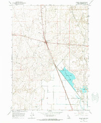
1964 Map of Market Lake
USGS Topo · Published 1965About this map
Market Lake and the surrounding Market Lake State Wildlife Management Area dominate this Jefferson County landscape, where the water's edge meets a complex system of local infrastructure. The transition from the wetlands of the Slough to the higher desert ground is marked by industrial and agricultural footprints, including a Radio Facility, a Storage Bin, and several Borrow Pit sites. These features reflect the mid-century development of the region's transportation and utility networks.
Find a feature on this map
26 named features on this map. Tap any name to fly to it.
Don’t see what you’re looking for? This feature index may not catch every label — zoom into the map to look around manually.
Map Details
Editions of this 1964 Market Lake Map
This is the sole edition of this map. No revisions or reprints were ever made.
Other maps of this area

1948 · Lewisville
USGS Topo · 1:24,000

1949 · Lewisville
USGS Topo · 1:24,000

1949 · Roberts
USGS Topo · 1:62,500

1949 · Roberts
USGS Topo · 1:24,000

1950 · Roberts
USGS Topo · 1:24,000

1955 · Idaho Falls
USGS Topo · 1:250,000

1958 · Idaho Falls
USGS Topo · 1:250,000

1964 · Kettle Butte NE
USGS Topo · 1:24,000
1964 · Deer Parks
USGS Topo · 1:24,000

1964 · Mud Lake SE
USGS Topo · 1:24,000