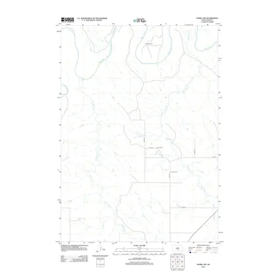
2012 Map of Hamill NW
USGS Topo · Published 2012About this map
The White River winds along the northern border of this South Dakota landscape, defining the topography of this segment of Tripp County. This region is characterized by expansive ranchlands and a drainage network dictated by seasonal waterways. Named family operations like Schooler Ranch, Nelson Ranch, and Fenenga Ranch are distributed across the section lines, connected by a network of rural roads including 324th Ave and 257th St. Two primary drainages, Black Dog Cr and No Moccasin Cr, cut south to north across the terrain toward the river valley. The map reveals the structured grid of the western prairie, where the placement of individual ranch houses and local access roads like 325th Ave reflect the enduring patterns of Great Plains land use and cattle ranching in the early 21st century.
Find a feature on this map
11 named features on this map. Tap any name to fly to it.
Don’t see what you’re looking for? This feature index may not catch every label — zoom into the map to look around manually.
Map Details
Editions of this 2012 Hamill NW Map
This is the sole edition of this map. No revisions or reprints were ever made.
Other maps of this area

1951 · Ideal NE
USGS Topo · 1:24,000

1952 · Reliance SW
USGS Topo · 1:24,000

1952 · Reliance SE
USGS Topo · 1:24,000

1952 · Hamill NW
USGS Topo · 1:24,000

1952 · Hamill NE
USGS Topo · 1:24,000

1955 · Mitchell
USGS Topo · 1:250,000

1959 · Mitchell
USGS Topo · 1:250,000

1971 · Hamill SE
USGS Topo · 1:24,000

1971 · Hamill
USGS Topo · 1:24,000
1978 · Kennebec SE
USGS Topo · 1:24,000