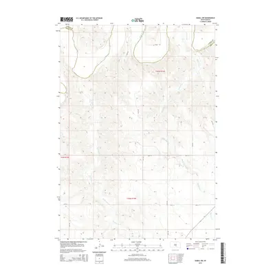
2015 Map of Hamill NW
USGS Topo · Published 2015About this map
The White River winds through the northern reaches of this South Dakota landscape, defining the jagged border shared by Lyman Co and Tripp Co. The terrain is characterized by a network of drainage channels including Black Dog Cr and No Moccasin Cr, which carve through the land south of the river. This 2015 survey illustrates a rural grid of section lines and gravel roads, such as Brule Rd and 324th Ave, that provide access across the township boundaries of t103n r74w, t102n r75w, and t102n r74w. The map preserves the spatial arrangement of the plains before further modern developments, showing the relationship between natural watercourses and the established survey lines of the Great Plains.
Find a feature on this map
14 named features on this map. Tap any name to fly to it.
Don’t see what you’re looking for? This feature index may not catch every label — zoom into the map to look around manually.
Map Details
Editions of this 2015 Hamill NW Map
This is the sole edition of this map. No revisions or reprints were ever made.
Other maps of this area

1951 · Ideal NE
USGS Topo · 1:24,000

1952 · Reliance SW
USGS Topo · 1:24,000

1952 · Reliance SE
USGS Topo · 1:24,000

1952 · Hamill NW
USGS Topo · 1:24,000

1952 · Hamill NE
USGS Topo · 1:24,000

1955 · Mitchell
USGS Topo · 1:250,000

1959 · Mitchell
USGS Topo · 1:250,000

1971 · Hamill SE
USGS Topo · 1:24,000

1971 · Hamill
USGS Topo · 1:24,000
1978 · Kennebec SE
USGS Topo · 1:24,000