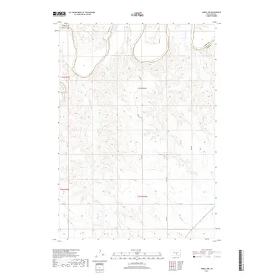
2017 Map of Hamill NW
USGS Topo · Published 2017About this map
The White River carves a distinctive path across the northern reaches of this landscape on the border of Lyman and Tripp counties. This section of South Dakota is defined by the sharp transition from the river valley's complex drainage patterns to the upland plateaus, where a geometric grid of section lines and rural roads organizes the terrain. Waterways like Black Dog Cr and No Moccasin Cr extend southward from the river, creating a dendritic network of coulees and draws that contrast with the open country.
Find a feature on this map
16 named features on this map. Tap any name to fly to it.
Don’t see what you’re looking for? This feature index may not catch every label — zoom into the map to look around manually.
Map Details
Editions of this 2017 Hamill NW Map
This is the sole edition of this map. No revisions or reprints were ever made.
Other maps of this area

1951 · Ideal NE
USGS Topo · 1:24,000

1952 · Reliance SW
USGS Topo · 1:24,000

1952 · Reliance SE
USGS Topo · 1:24,000

1952 · Hamill NW
USGS Topo · 1:24,000

1952 · Hamill NE
USGS Topo · 1:24,000

1955 · Mitchell
USGS Topo · 1:250,000

1959 · Mitchell
USGS Topo · 1:250,000

1971 · Hamill SE
USGS Topo · 1:24,000

1971 · Hamill
USGS Topo · 1:24,000
1978 · Kennebec SE
USGS Topo · 1:24,000