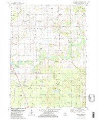
1981 Map of Hamilton East
USGS Topo · Published 1981About this map
Rabbit River and Silver Creek wind through a landscape defined by agricultural tradition and the mid-century development of the local energy industry. The map documents an extensive Gas Storage Area in the township of Overisel, complemented by several Oil Fields further south in Monterey. Small rural centers such as Bentheim, Diamond Springs, and Oakland serve as focal points for the community, anchored by landmarks like Bentheim Chapel and Oakland Ch. The southwestern quadrant is largely dedicated to the Allegan State Game Area, where the terrain transitions from cultivated fields to the lowland marshes of Beaver Meadow and the shores of Goose Lake. Transportation infrastructure is prominently featured, ranging from the Chesapeake and Ohio railroad line near Hamilton to private aviation facilities like the Busscher Landing Strip.
Find a feature on this map
48 named features on this map. Tap any name to fly to it.
Don’t see what you’re looking for? This feature index may not catch every label — zoom into the map to look around manually.
Map Details
Editions of this 1981 Hamilton East Map
2 editions found
Other maps of this area

1928 · Fennville
USGS Topo · 1:62,500

1929 · Holland
USGS Topo · 1:62,500

1931 · Fennville
USGS Topo · 1:62,500

1932 · Holland
USGS Topo · 1:62,500

1958 · Allegan
USGS Topo · 1:62,500

1958 · Grandville
USGS Topo · 1:62,500

1958 · Racine
USGS Topo · 1:250,000

1958 · Grand Rapids
USGS Topo · 1:250,000

1961 · Grand Rapids
USGS Topo · 1:250,000

1962 · Grand Rapids
USGS Topo · 1:250,000