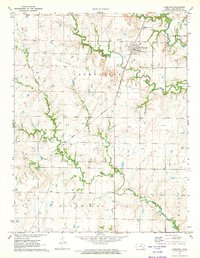
1971 Map of Hamilton
USGS Topo · Published 1973About this map
Hamilton serves as the primary hub of this eastern Kansas landscape, situated where the Atchison Topeka and Santa Fe railroad crosses through the Janesville township. The map details a rural community defined by its watercourses, with Slate Creek and Homer Creek meandering through the prairie. Local history is anchored by several rural burial grounds, including Township Cem and Ott Cem, which provide essential points of reference for genealogists. The influence of the oil industry is evident through numerous Oil Wells and a prominent Pipeline cutting across the terrain. To the south, the Utopia Community Ch marks a small gathering point within the Bachelor township. This survey illustrates the late-twentieth-century balance between traditional agriculture, early industrial extraction, and the established rail infrastructure that linked these small Greenwood County settlements.
Find a feature on this map
23 named features on this map. Tap any name to fly to it.
Don’t see what you’re looking for? This feature index may not catch every label — zoom into the map to look around manually.
Map Details
Editions of this 1971 Hamilton Map
This is the sole edition of this map. No revisions or reprints were ever made.
Other maps of this area

1885 · Eureka
USGS Topo · 1:125,000

1888 · Emporia
USGS Topo · 1:125,000

1888 · Eureka
USGS Topo · 1:125,000

1894 · Emporia
USGS Topo · 1:125,000

1894 · Eureka
USGS Topo · 1:125,000

1955 · Wichita
USGS Topo · 1:250,000

1955 · Hutchinson
USGS Topo · 1:250,000

1958 · Wichita
USGS Topo · 1:250,000

1959 · Hutchinson
USGS Topo · 1:250,000

1967 · Madison SW
USGS Topo · 1:24,000