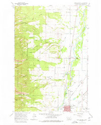
1967 Map of Hamilton North
USGS Topo · Published 1978About this map
The Bitterroot River valley is the centerpiece of this 1960s survey, showing the development of Hamilton and the surrounding agricultural landscape of the Bitterroot Valley. To the west, the terrain rises sharply into the Bitterroot National Forest, where steep canyons like Blodgett Creek and Mill Creek emerge from the mountains. This area illustrates the critical intersection of water management and western settlement, with the Bitterroot Supply Ditch, Republican Ditch, and Corvallis Canal feeding the valley floor. Small communities such as Woodside and Riverside sit along the valley corridor, while local history is preserved at the Blodgett Cem. Mid-century infrastructure is well-represented, from the Burlington Northern railroad lines to the Hamilton Airport and even a Drive-in Theater near the river, reflecting the region's mid-century growth.
Find a feature on this map
41 named features on this map. Tap any name to fly to it.
Don’t see what you’re looking for? This feature index may not catch every label — zoom into the map to look around manually.
Map Details
Editions of this 1967 Hamilton North Map
Other maps of this area

1901 · Hamilton
USGS Topo · 1:125,000

1956 · Hamilton
USGS Topo · 1:250,000

1959 · Hamilton
USGS Topo · 1:250,000

1960 · Hamilton
USGS Topo · 1:250,000

1964 · Hamilton
USGS Topo · 1:250,000

1964 · Hamilton South
USGS Topo · 1:24,000

1964 · Ward Mountain
USGS Topo · 1:24,000
1964 · Mountain House
USGS Topo · 1:24,000
1966 · Printz Ridge
USGS Topo · 1:24,000
1966 · Gash Point
USGS Topo · 1:24,000