Loading...
Loading map...1901 Map of Hamilton
USGS Topo · Published 1949About this map
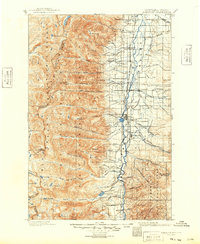
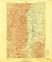
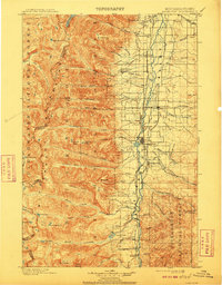
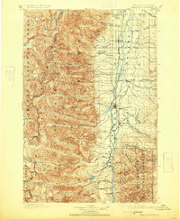
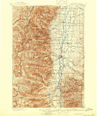
Hamilton serves as the focal point of this late 19th-century landscape, positioned along the Northern Pacific R. R. (Bitterroot Branch). The Bitterroot Valley is defined by a sophisticated network of irrigation systems such as the Republican Ditch, Hedge Ditch, and the curiously named New Old Ditch, which support the agricultural settlements of Victor, Corvallis, and Darby. To the west, the Bitterroot Range rises sharply, marked by high-altitude features like Canyon Peak and Como Lake.
Find a feature on this map
95 named features on this map. Tap any name to fly to it.
Don’t see what you’re looking for? This feature index may not catch every label — zoom into the map to look around manually.
Map Details
Date Portrayed1901
Date Published1949
PublisherU.S. Geological Survey
Map TypeTopographic
Scale1:125,000
Physical Dimensions17.1 x 20.8 inches
Editions of this 1901 Hamilton Map
6 editions found

Historical Maps of Hamilton Through Time
6 maps found


Featured Locations
Source Details
SourceU.S. Geological Survey
CopyrightPublic Domain