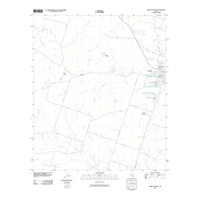
2010 Map of Hamilton West
USGS Topo · Published 2010About this map
Hamilton and the small settlement of Midway anchor this Central Texas landscape, which is defined by an extensive network of water management and local ranch roads. The western edge of the county seat is shown alongside the Hamilton Municipal Airport, while the surrounding countryside is characterized by numerous agricultural water controls, including the Soil Conservation Service Site 4 Reservoir and several related dams along Pecan Creek.
Find a feature on this map
47 named features on this map. Tap any name to fly to it.
Don’t see what you’re looking for? This feature index may not catch every label — zoom into the map to look around manually.
Map Details
Editions of this 2010 Hamilton West Map
This is the sole edition of this map. No revisions or reprints were ever made.
Other maps of this area

1888 · Hamilton
USGS Topo · 1:125,000

1894 · Hamilton
USGS Topo · 1:125,000

1954 · Brownwood
USGS Topo · 1:250,000

1956 · Gustine
USGS Topo · 1:62,500

1956 · Gentrys Mill
USGS Topo · 1:24,000

1956 · Pottsville
USGS Topo · 1:62,500
1956 · Ohio
USGS Topo · 1:24,000

1956 · Hico
USGS Topo · 1:62,500

1956 · Hamilton
USGS Topo · 1:62,500

1956 · Hamilton West
USGS Topo · 1:24,000