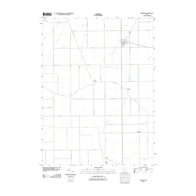
2010 Map of Hamler
USGS Topo · Published 2010About this map
The village of Hamler sits at a geographic crossroads in Henry County, defined by a rigid grid of agricultural roads and the passage of several waterways. This early 21st-century landscape is dominated by the drainage patterns of South Turkeyfoot Creek and Brush Creek, which weave through the flat farmland. The layout of the region is punctuated by small rural settlements such as Gallup and Prentiss, alongside significant local burial sites including Saint Pauls Cemetery and the Marion Township Cemetery. In town, the Hamler Post Office serves as a central landmark for the community. The map reveals the persistence of rural tradition in Ohio, where the intersection of named roads like County Rd E and County Rd 10 forms the skeleton of local navigation and land ownership.
Find a feature on this map
49 named features on this map. Tap any name to fly to it.
Don’t see what you’re looking for? This feature index may not catch every label — zoom into the map to look around manually.
Map Details
Editions of this 2010 Hamler Map
This is the sole edition of this map. No revisions or reprints were ever made.
Other maps of this area

1908 · Ottawa
USGS Topo · 1:62,500

1908 · Napoleon
USGS Topo · 1:62,500

1909 · Mc Clure
USGS Topo · 1:62,500

1953 · Fort Wayne
USGS Topo · 1:250,000

1956 · Fort Wayne
USGS Topo · 1:250,000

1956 · Toledo
USGS Topo · 1:250,000

1959 · Florida
USGS Topo · 1:24,000

1960 · Deshler
USGS Topo · 1:24,000

1960 · Ottawa
USGS Topo · 1:24,000
1960 · New Bavaria
USGS Topo · 1:24,000