
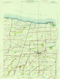
1932 Map of Hamlin
USGS Topo · Published 1932About this map
Lake Ontario borders this northern edge of Monroe County, where the rocky promontory of Devils Nose stands as a prominent landmark along the shoreline. In the early 1930s, the landscape was a grid of orchards and farmland, interconnected by gravel roads like Moscow Road and German Church Road. The New York Central railroad cuts through the center of the sheet, supporting the commercial hubs of Hamlin Station and Hamlin.
Find a feature on this map
50 named features on this map. Tap any name to fly to it.
Don’t see what you’re looking for? This feature index may not catch every label — zoom into the map to look around manually.
Map Details
Editions of this 1932 Hamlin Map
This is the sole edition of this map. No revisions or reprints were ever made.
Other maps of this area

1897 · Albion
USGS Topo · 1:62,500

1897 · Oak Orchard
USGS Topo · 1:62,500

1899 · Hamlin
USGS Topo · 1:62,500

1899 · Brockport
USGS Topo · 1:62,500

1932 · Spencerport
USGS Topo · 1:24,000

1934 · Spencerport
USGS Topo · 1:24,000

1934 · Brockport
USGS Topo · 1:24,000
1934 · Hilton
USGS Topo · 1:24,000

1935 · Hamlin
USGS Topo · 1:24,000

1944 · Holley
USGS Topo · 1:31,680