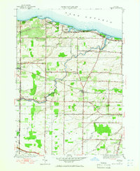
1952 Map of Hamlin
USGS Topo · Published 1965About this map
Lake Ontario shorelines and agricultural hinterlands define this 1952 revision of the Hamlin area, documenting a landscape of rural schoolhouses and fruit-growing potential. The map highlights the early footprint of Hamlin Beach State Park, which includes Yanty Creek and the notable Devils Nose promontory. Inland, the town is partitioned into numbered school districts, such as School No 12 and School No 13, alongside private institutions like St Johns Parish Hall Sch.
Find a feature on this map
43 named features on this map. Tap any name to fly to it.
Don’t see what you’re looking for? This feature index may not catch every label — zoom into the map to look around manually.
Map Details
Editions of this 1952 Hamlin Map
2 editions found
Other maps of this area

1897 · Albion
USGS Topo · 1:62,500

1897 · Oak Orchard
USGS Topo · 1:62,500

1899 · Hamlin
USGS Topo · 1:62,500

1899 · Brockport
USGS Topo · 1:62,500

1932 · Hamlin
USGS Topo · 1:24,000

1932 · Spencerport
USGS Topo · 1:24,000

1934 · Spencerport
USGS Topo · 1:24,000

1934 · Brockport
USGS Topo · 1:24,000
1934 · Hilton
USGS Topo · 1:24,000

1935 · Hamlin
USGS Topo · 1:24,000