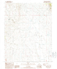
1987 Map of Hammil Valley
USGS Topo · Published 1987About this map
Hammil Valley serves as the focal point for this Mono County landscape, characterized by a transition from industrial activity to agricultural and natural spaces. The valley floor contains the Hammil (Site) and a local Landing Strip, surrounded by numerous water sources such as Pellisier Creek, Birch Creek, and Lone Tree Creek. To the west, the topography rises sharply into the Volcanic Tableland, where mineral extraction is prominent. Numerous Open Pit Mines and the Silver Reef Mine are scattered across the high ground near Blind Spring Hill and Yellowjacket Canyon. The eastern edge of the quadrangle is defined by the protected wilderness of the Inyo National Forest, where steep canyons like Falls Canyon drop toward the valley floor.
Find a feature on this map
20 named features on this map. Tap any name to fly to it.
Don’t see what you’re looking for? This feature index may not catch every label — zoom into the map to look around manually.
Map Details
Editions of this 1987 Hammil Valley Map
This is the sole edition of this map. No revisions or reprints were ever made.
Other maps of this area

1914 · Mt. Morrison
USGS Topo · 1:125,000

1917 · White Mountain
USGS Topo · 1:125,000

1947 · Mariposa
USGS Topo · 1:250,000

1948 · Mariposa
USGS Topo · 1:250,000

1953 · Casa Diablo Mtn
USGS Topo · 1:62,500

1957 · Mariposa
USGS Topo · 1:250,000

1962 · Benton
USGS Topo · 1:62,500

1962 · Glass Mountain
USGS Topo · 1:62,500

1962 · White Mtn. Peak
USGS Topo · 1:62,500

1963 · Mariposa
USGS Topo · 1:250,000