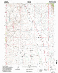
1994 Map of Hammil Valley
USGS Topo · Published 1997About this map
Blind Spring Hill and the Volcanic Tableland dominate this high-desert landscape in Mono County, where the desert floor meets the rising slopes of the Inyo National Forest. This 1994 revision, based on imagery dating back to 1954, documents a region defined by extraction and resource management. Numerous Open Pit Mines and scattered prospects are mapped across the western ridges, including the Silver Reef Mine near Yellowjacket Canyon. The settlement of Hammil (Site) is recorded as a former location on the valley floor, adjacent to a utility corridor and a local Landing Strip. Water resources are central to the map's details, showing a network of aqueducts and wells supporting agricultural activity like feedlots and the ecologically sensitive Fish Slough, which is designated here as part of an Environmental Area of Critical Concern.
Find a feature on this map
43 named features on this map. Tap any name to fly to it.
Don’t see what you’re looking for? This feature index may not catch every label — zoom into the map to look around manually.
Map Details
Editions of this 1994 Hammil Valley Map
This is the sole edition of this map. No revisions or reprints were ever made.
Other maps of this area

1914 · Mt. Morrison
USGS Topo · 1:125,000

1917 · White Mountain
USGS Topo · 1:125,000

1947 · Mariposa
USGS Topo · 1:250,000

1948 · Mariposa
USGS Topo · 1:250,000

1953 · Casa Diablo Mtn
USGS Topo · 1:62,500

1957 · Mariposa
USGS Topo · 1:250,000

1962 · Benton
USGS Topo · 1:62,500

1962 · Glass Mountain
USGS Topo · 1:62,500

1962 · White Mtn. Peak
USGS Topo · 1:62,500

1963 · Mariposa
USGS Topo · 1:250,000