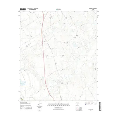
2016 Map of Hammond
USGS Topo · Published 2016About this map
Tidwell Prairie defines the central topography of this Robertson County landscape, where rural life is anchored by family-named roads and remote burial grounds. The settlement of Hammond sits along the rail line and major thoroughfare, while Salter occupies the western edge near the Little Brazos River Diversion Channel. This 2016 survey documents a complex network of creeks, including Walnut Cr and Big Willow Cr, which drain the prairie land. Genealogists will find significant value in the detailed placement of the Bethlehem Cem, Saint Paul Cem, and the uniquely named Cotton-Cottonwood-Shilo Cem. The map reveals a transition between agricultural prairie and the river bottomlands, marked by water bodies like Hall Lake and Robertson Lake. The intricate road system, from Shiloh Baptist Church Rd - Williamson Rd to S Tidwell Prairie Rd, illustrates the persistent infrastructure of these historic Texas communities.
Find a feature on this map
62 named features on this map. Tap any name to fly to it.
Don’t see what you’re looking for? This feature index may not catch every label — zoom into the map to look around manually.
Map Details
Editions of this 2016 Hammond Map
This is the sole edition of this map. No revisions or reprints were ever made.
Other maps of this area

1954 · Waco
USGS Topo · 1:250,000

1954 · Austin
USGS Topo · 1:250,000

1955 · Waco
USGS Topo · 1:250,000

1961 · Hearne North
USGS Topo · 1:24,000

1961 · Baileyville
USGS Topo · 1:24,000

1962 · Calvert
USGS Topo · 1:24,000

1962 · Maysfield
USGS Topo · 1:24,000

1962 · Hammond
USGS Topo · 1:24,000

1962 · Reagan
USGS Topo · 1:24,000

1962 · Bremond
USGS Topo · 1:24,000