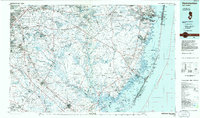
1984 Map of Hammonton
USGS Topo · Published 1986About this map
Wharton State Forest dominates the interior of this 1984 survey, preserving a massive expanse of the Pine Barrens where the Batsto River and Mullica River converge. This planimetric study captures the region during a period of significant suburban expansion along the western fringe in Lindenwold and Berlin, while the eastern shore shows the established vacation communities of Long Beach and Island Beach. The landscape is a study in contrasts, from the sprawling Fort Dix Military Reservation in the north to the specialized institutional grounds of the Ancora Psychiatric Hospital. Significant transportation corridors, including the Atlantic City Expressway and the Garden State Parkway, slice through the dense woodlands, illustrating the infrastructure required to connect the Philadelphia suburbs with the Jersey Shore. Coastal protected areas like the Edwin B. Forsythe National Wildlife Refuge and the iconic Barnegat Light stand as landmarks along the intricate network of bays and inlets.
Find a feature on this map
54 named features on this map. Tap any name to fly to it.
Don’t see what you’re looking for? This feature index may not catch every label — zoom into the map to look around manually.
Map Details
Editions of this 1984 Hammonton Map
3 editions found
Other maps of this area

1884 · Whitings
USGS Topo · 1:62,500

1887 · Atlantic City
USGS Topo · 1:62,500

1888 · Bordentown
USGS Topo · 1:62,500

1888 · Pemberton
USGS Topo · 1:62,500

1888 · Barnegat
USGS Topo · 1:62,500

1888 · Little Egg Harbor
USGS Topo · 1:62,500

1888 · Mount Holly
USGS Topo · 1:62,500

1888 · Asbury Park
USGS Topo · 1:62,500

1888 · Cassville
USGS Topo · 1:62,500

1888 · Long Beach
USGS Topo · 1:62,500
Featured Places
- Toms River, NJ
- Cherry Hill Township, NJ
- Vineland, NJ
- Jackson Township, NJ
- Sicklerville, Winslow Township